From London to Bali Indonesia on a YAMAHA TDM900, 42,000km

Friday, April 27, 2007

After 3 days in Cameron Highlands it was time to head down south to Kuala Lumpur (KL). Kuala Lumpur has its origins in the 1850s, when the Malay Chief of Klang sent some Chinese upriver to what is now KL, to open new and larger tin mines and since then had become to be the federal capital of Malaysia. As we arive along one of many modern highways that crisis cross and encircle KL, we are presented with a skyline of a modern day cosmopolitan city ( small in international standards, pop only 1,8 million) that has left history of tin mining well behind (image 1).Malaysia prosperity has been helped by having the oil in its territorial waters off south China sea that produce some 750,000 barrels/day (Oil - exports: 230,200 bbl/day (2003)). But more importantly having leaders with vision to push the country forward with long term goals and no one has been more influential (in my opinion) than Dr. Mahathir who served as the president of Malaysia for 21 years from 1981. And over a short period of time Malaysia has transformed from a producer of raw materials into an emerging multi-sector economy, growth was almost exclusively driven by exports - particularly of electronics.

It was also time to meet up with few friendly local bike mads, Arie, Chang, Fino and Chong, (2 TDM and a VFR) who invited us for great dinner at the local Chinese. Unfortunately Arie (blue TDM) has had a little spill in Southern Thailand and is recovering to get back on the bike.The imported bikes are heavily taxed over here, 120% but there are few big bikes around in KL. But the majority of the bikes are the locally produced/assembled (sub 135cc) Honda, Yamaha & Modenas (Malaysian manufacture)


It was time to head to Cameron Highlands, slightly, if not the only cool (temp) in whole of Malaysia (except the shopping malls). About 250km south east into the mainland from Penang.As we head south and inland we are surprised to see how green the whole landscape is. The highways and roads are of amazingly high standards, just as in western Europe.To reach Cameron Highlands we had to leave the main north-south highway and head east through winding country lanes through, what mostly looked like tropical rain forest.The Highlands were named after William Cameron, a British colonial government surveyor who discovered the plateau during a mapping expedition in 1885. The fame of Cameron Highlands then grew during the colonial era when British planters realised the potential of its fertile mountain slopes for growing tea, then a prized commodity. The Cameron Highlands are still home to many tea plantations (image ), being Malaysia's largest tea-producing region. The area is also known as a major supplier of legumes and vegetables to both Malaysia and Singapore with its many farms, and with its cool temperature through out the year, it is one of Malaysia's prime tourist destinations. Actually it felt very cold during the night while we were there.
(image 3)Narrow sealed track leading to the one of the highest points in Malaysia

While in George Town, it was also time to meet up with Michelle who very kindly showed us around the town and visit the botanical garden with a relaxing waterfall that is popular with the locals as well as the monkeys. /

Durante nuestra estancia en Georgetime nos reunimos con Michelle, una amiga de una amiga en Londres, Leonie. Michelle nos dio una vuelta por la ciudad y nos llevo al jardin botanico, donde pudimos admirar la cascada, muy popular entre la poblacion local y entre la poblacion de monos del parque!!

Friday, April 20, 2007

George Town being one of the earliest, most established urban centres in Malaya, Chinese influence has always been more evident in urban areas due to their superior numbers while the Malays, until recent times, have largely resided in the rural areas.The old commercial center of Penang and still the most attractive bit was and still is dominated by the Chinese population. The early Chinese immigrants arriving in George Town from southern regions of China, had over a short period of time formed economically powerful and influential clans by sticking together when settling in Penang. This is rerflected by elegant mentions and temples that were build by the clans in their own quarters and had brought the craftmen from native China. The following generations of the Nouveau-riche Chinese millionaires of the olden days built themselves stately mansions (images) and a great many of the shophouses and residences found in George Town were built in the style of Straits-Chinese architecture.


Georgetown es uno de los primeros y mejor establecidos asentamientos urbanos de Malasia. La influencia china en la isla es muy evidente, sobre todo en las zonas urbanas donde la proporcion de poblacion china sobrepasa la de origen malayo, la cual se ha restringido hasta hace poco a las zonas rurales.
El antiguo centro, la zona comercial de Penang, es la zona mas bonita de la ciudad, y aun en la actualidad esta dominada por la poblacion de origen chino.
Los primeros inmigrantes chinos llegaron a Georgetown desde varias regiones del sur de China. En principio establecieron asociaciones o clanes muy poderosos y con gran influencia en los asuntos de la ciudad. La existencias de dichos clanes es evidente aun hoy en dia, en las grandes y elegantes mansiones y templos (ver fotos) que adornan la ciudad, asi como en las tiendas/viviendas que llenan el centro de la ciudad, construidas en estilo Chino-Estrecho (estrecho se refiere a los estrechos entre Malasia e Indonesia).


The View of the mainland and the causeway from the Penang Hill 800m above sea level and took an half and hour to get there with the cable car (image ) / Vistas del puente que conecta la isla con el resto de la peninsula desde Penang Hill, a 800metros sobre el nivel del mar. Tardamos algo asi como media hora en llegar a la cima a bordo del tren (movido con cables a traccion). (ver fotos).

Kek Lok Si (image below) at the foothill of Penang Hill is the largest Buddhist temple in Southeast Asia. Known as the Temple of Ten Thousand Buddhas, it was largely built by artisans and worksmen from China in the 19th century. But we did not find it very impressive. / Templo de Kek Lok Si (foto inferior) al pie de la colina Penang Hill, es el mayor templo budista del sudeste asiatico. Conocido como el Templo de los Diez Mil Budas, fue construido en su mayor parte por artesamos y obreros traidos de China en el siglo 19. La verdad es que a nosotros no nos impresiono mucho.


As we head to Penang, our first destination in Malaysia, it is quite easy to see the contrast between Thailand that we left behind, now we were riding along a highway similar that of Western Europe. And motorcycles are allowed on the highway! And not subject to toll. And there is and abundance of green all around. /

Al dirigirnos hacia Penang, nuestro primer destino en Malaysia, se pueden ver claramente las diferencias con la Tailandia que dejamos atras: ahora nos encontramos conduciendo por carreteras con caracteristicas similares a las de Europa occidental. Hemos tenido suerte, las motos no pagan en las autopistas de peaje, y, aunque parezca mentira, aqui permiten a los ciclomotores circular por autopista!!. Hay muchisima vegetacion, verde por todas partes.


The island of Penang, 180 km south of the border crossing is linked to the mainland via a causeway. The first sites of the Penang we come across are the distant green hills of the island’s center, surrounded by the tall high-rise office and residential buildings that fills the east coast.
Segun nos acercamos a Penang, a 180 km al sur de la frontera con Tailandia, hemos de cruzar un puente de mas de 6km para llegar a la isla.Lo primero que podemos apreciar son las verdes colinas al fondo, en el centro de la isla, rodeadas de torres de gran altura, oficinas, centros comerciales y bloques de vivienda se extienden hacia la costa este.

Penang, originally part of the Malay sultanate of Kedah, was given to the British East India Company in 1786 by the Sultan of Kedah, in exchange for military protection from Siamese and Burmese armies who were threatening Kedah. On 11 August 1786, Captain Francis Light, known as the founder of Penang, landed in Penang and renamed it Prince of Wales Island.In 1826, became under the British administration in India, moving to direct British colonial rule in 1867. And became a state of the Federation of Malaya. Panag was occupied by the Japanese during the WW2 and gained independence in 1957 form the British who returned to Malaysia at the end of the WW2. The population of Penang (highest population density in Malaysia with 2,031.74 people per square kilometre) comprise mainly of Chinese (42%) Malay (40%) and Ehnic Indian (10%)Today Penang remains a thriving commercial (and now industrial) centre with a relatively high standard of living thanks to large investments made in the 80's in setting up one of the largest electronics manufacturing bases in AsiaArchitecture in Penang is a combination of British coalescing with local, Chinese, Indian, Islamic and various other elements. (images ) /

Penang, originalmente parte del sultanato de Kedah, fue cedida a la Compania Britanica de las Indias Orientales en 1786 por el sultan de Kedah a cambio de proteccion militar frente a los ejercitos siameses y burmeses. El 11 de agosto de 1786 el Capitan Francis Light, conocido como el fundador de Penang, llego a Penang y cambio su nombre por el de Isla del Principe de Gales. En 1826 quedo bajo el mando de la administracion britanica de la India, pasando a estar bajo gobierno britanico colonial en 1867, formando parte de la Federacion de Malasia. Penang sufrio tambien la ocupacion japonesa durante la segunda guerra mundial, pasando de nuevo a ser una colonia britanica al final de la guerra y consiguiendo por fin su independencia del gobierno britanico en 1957. La poblacion de Penang (con la densidad mas alta de toda Malasia con 2.034 personas por kilometro cuadrado) esta compuesta por 3 grupos etnicos bien distintos: chinos (42%), malayos (40%) e indios (10%).En la actualidad Penang es aun un importante enclave comercial (e incluso industrial) con un alto nivel de vida gracias a las grandes inversiones de las que disfruto en los anos 80 y que sirvieron para establecer uno de los mayores fabricas de componentes electronicos de toda Asia. La arquitectura de Penang es una mezcla de arquitectura colonial britanica con fuertes influencias china, india e islamicas (ver fotos)


After spending 7 weeks in total and riding 5,500km, it was time to say good bye to Thailand. Which has been one of the countries most hospitable so far , even with the large number of tourists the country receives. Some 11-12 million tourists visit Thailand annually contributing some 15% of the GDP!
Thai people have been quite friendly and helpful throughout the whole time and food has been very good. /

Despues de 7 semanas y un total de 5.500km recorridos, era ya hora de despedirse de Thailandia, el cual ha sido uno de los paises mas hospitalarios de los que hemos visitado, y eso a pesar de la gran cantidad de turistas que el pais recibe, aproximadamente entre 11-12 millones de turistas a lo largo del ano, que suponen un 15% del PBI !!!!! Los thailandeses han sido la mar de amables y siempre dispuestos a ayudar, y la comida por lo general ha sido bastante buena.


Border crossing at the Malaysian side. / Puesto fronterizo, desde el lado de Malasia


Roads have been very nice, drivers not too bad, not too crazy or impatient although according to Thai statistics Thailand claims to have the highest road fatalities per capita in the world which we find hard to believe, really. However there's large number of fourwheels (mainly pick-up trucks) and motorcycles on the roads. /
Las carreteras son estupendas, los conductores tampoco estan mal, no son ni impacientes ni conducen como locos (cosa que si ocurre en otros paises por los que hemos pasado) a pesar de que, segun las estadisticas, Thailandia tiene el mayor numero de muertes en carretera por habitante del mundo, algo que realmente nos cuesta creer. Lo que si que hay que resaltar es el elevado numero de camiones pick-up y motocicletas.

The scenery along the roads was very nice and varied, particularly in the mountainous north and around the island of Phuket and Krabi, with their stunning beaches and limestone formations. /
Los paisajes a lo largo de las carreteras por las que hemos pasado han sido preciosos, y muy variados, sobre todo en las zonas montanosas del norte del pais y, en el sur, en la isla de Phuket y Krabi, con playas bellisimas y acantilados rocosos impresionantes.


Petrol of good quality - 95 unleaded at approx. 26 Baht or 40p a litre. /La gasolina es de muy buena calidad, 95 octanos, sin plomo, aproximadamente 26 Baht (60centimos de euro) el litro.

Architecturally it wasn't the most thought-provoking or mind-boggling place we have visited, but very pleasant nevertheless. Most of the cities and towns felt new and with little or no history. However as an unintentional diversion from our original plans we are very pleased to have visited Thailand. /
Arquitectonicamente hablando no ha sido el pais con los lugares mas impresionantes o que nos han dado mas que pensar, pero esta bien, vaya. La mayoria de las ciudades y pueblos por los que hemos pasado nos han dado la sensacion de 'muy nuevo', con apenas historia. Sin embargo, y como parte del desvio de nuestra ruta original, la verdad es que estamos muy contentos de haber visitado Thailandia.

Total distance at the Thailand - Malaysia border 28,065km from London. / Distancia total recorrida desde Londres hasta la frontera Thailandia/Malasia, 28.065 km

Friday, April 13, 2007


We arrived in Had-Yai for the local Yew Year celebrations on the 12 & 13th of April. And conveniently the locals celebrate it with splash, no one is spared! (no we were not spared either). Thais would drive around in the pic-ups and motor bikes whole day and night getting wet. Buckets of water is often poured from top storeys of the apartment flats to make life difficult for those who seek to stay dry (impossible option). But the Thais are a very light hearted bunch and the two days are enjoyed by everyone young and old.
Llegamos a Hat-Yai justo a tiempo para las fiestas del Ano Nuevo budista el 12 y 13 de abril. Y la gente aqui lo celebra mojando a todo bicho viviente, nadie escapa a las pistolas de agua, cubos, mangueras, botellas, barriles...y por si os lo estabais preguntando, no, nosotros tampoco nos salvamos, segun salimos a la calle el dia 13 nos llovieron los cubos de agua y pasamos el resto del dia empapados de pies a cabeza, y pasandolo pipa!!. Los tailandeses se dedican a conducir por las calles del centro en pick-ups, rickshaws o motos, lanzando y recibiendo agua a mansalva. La gente incluso tira cubos de agua desde los balcones y ventanas. Es imposible mantenerse seco, imposible. Y la verdad es que todo el mundo lo toma con mucho humor, son dos diasen los que todo el mundo lo pasa estupendamente, tanto ninos como mayores.

But unfortunately not all is as peaceful as it seems. This part of southern Thailand has been experiencing some extremist violence (bombs and shootings with a increasing brutality) that has been carried out by some Islamist group or another. The southern provinces boardering Malaysia are home to most of the Muslim population of the Thailand but the ethnic mix in places we have come across for far seems quite even, a mixture is Thai Buddhist, Thai Muslims and the Chinese and it seem that is a very small minority that is spoiling it for the vast majority.
Sin embargo no todo en el sur de Tailandia es tan pacifico como aqui parece. En los ultimos anos la region del sur del pais ha sufrido la violencia de varios grupos extremistas islamicos (bombas y ataques de una brutalidad creciente). Las provincias del sur, en la frontera con Malasia, albergan la mayoria de la poblacion musulmana de Tailandia, y las proporciones ethnicas en algunas poblaciones llegan a ser bastante equilibradas entre tais musulmanes, tais budistas y chinos. Como siempre, una pequena minoria es la que esta haciendo la vida imposible para una gran pacifica mayoria.


Heading further south inland away from the cost line towards the town of Had-Yai (on excellent roads as usual), the landscape is a diversity of rice fields, palm oil and rubber (image 2 & 3) plantations.
Nos dirigimos hacia el sur, alejandonos de la costa, hacia la ciudad de Hat-Yai (la carretera en magnificas condiciones, como es normal). El paisaje es una mezcla de arrozales, plantaciones de palma y caucho (fotos 2 y 3).


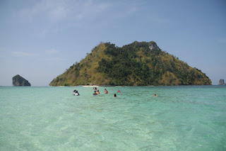
As we head southwest around Bay of Thailand the next recommended destination is Krabi, with a pop of 25,000 is very popular with the Scandinavian and there seems to be a constant flow even in the low season. Just like Phang Nga, the main attractions are the boat trips to the surrounding islands in the Gulf of Thailand. We managed to find a nice, cheap and cheerful bungalow (image 1) off the main road and before we knew it, we had spent six days there!.
Siguiendo nuestro camino en direccion sur-oeste a lo largo de la Bahia de Tailandia, nuestro proximo destino es Krabi, con una poblacion de aprox. 25.000 hab., es un destino turistico muy popular entre los escadinavos, y parece que incluso en temporada baja, la ocupacion es bastante buena.
Como en Phang Nga, las atracciones mas populares son los paseos en barco por las islas mas cercanas. Encontramos un sitio bastante bonito y a precio razonable, un bungalow (foto 1) alejado de la carretera principal en unos jardines preciosos...y casi sin darnos cuenta nos pasamos 6 dias alli!!

Thursday, April 05, 2007

Heading back to the mainland from Phuket, our next stop is Phang-nga. The town itself has nothing much to offer except it is the ideal place for taking a boat trip to the bay on a long-tail boat (image 1), part of an extensive national parkof Phang-nga. /
De vuelta a la peninsula, nuestro siguiente destino es Phang-Nga. El pueblo en si no es gran cosa, pero es el sitio ideal para reservar billete en uno de los famosos paseos en barco (foto 1) que se organizan en la bahia que forma parte del gran Parque Natural de Phang-Nga.

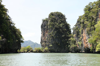
Most of the sheltered bay along the costline is covered in mangroves (2). Beyond the mangroves, sunken caverns and startling rock formations rising out of the sea extends for miles and miles in to the sea (images below). The limestone cliffs and islands are uninhabited except for one which was settled by Malay fishing families some 800 years ago and now has developed in to community of over 2000 (image 3). But these days most of the lively hood depends on the tourist visiting the bay. Apparently the some of the cave paintings found in the caves date back some 3000 years (4). /

Gran parte de la costa a lo largo de la bahia se encuentra cubierta por manglares (foto 2). Mas alla de los manglares, formaciones rocosas de gran bellezas, cuevas y cavernas se extienden millas y millas hacia mar adentro (fotos siguientes). Los acantilados de roca caliza y las innumerables islas de la amlia bahia no estan habitadas, con la excepcion de la "isla musulmana", una isla que fue colonizada por familias de pescadores de origen malayo hace unos 800 anos, y que se ha convertido en una gran comunidad musulmana de mas de 2000 personas (foto 3). En la actualidad la mayor parte de estas familias viven del turismo de la bahia.
Segun nos dijo nuestro guia, en una de las cuevas en una de las islas se pueden admirar unas pinturas rupestres con mas de 3000 anos de antiguedad (foto 4)