From London to Bali Indonesia on a YAMAHA TDM900, 42,000km

Friday, February 23, 2007


The highlight of Phonsovan is the sites of Jars. The Jars which are littered over three main sites, said to have been (man) made 2000 years ago for either for storeing food or water. not quite sure (image 1). But the site is also showcase for Laos' suffering during the Indo-China war.
Laos, the most bombed country on earth! For ten years between 1963 and 73, 2 million tonnes of bombs were dropped by the US Air force.
During the Indo-China war, Laos was recognised as a neutral country with no foreigner forces on its soil. But the Vietnamese used Laos as a spring board for for attacking the french colonist in the first Indo-China war and never withdrew.
By 1970, some 75,000North Vietnamese troops was deployed in Laos supplying communist units in Cambodia and South Vietnam. By then South Vietnam was under US control with the aim of halting the Communism in Indo-China.
US interventions in Laos initiated with the setting up and training of guerrilla forces of the Hmong Hill Tribe but was unable to halt the flow of weapons and troops from North Vietnam to the south along the Ho Chi Minh Trail. So the carpet bombing of Laos to stone age started. By '73 nearly 600,000sorties had flown over Laos by US forces dropping on average of one planeload of bombs every 8 min, 24 hrs a day for 9 years! By the end of the war 2 million tons was dropped, which is greater than the total bombs dropped by the US forces over Europe in the WW2 and equates to in the half a ton of bombs per every Laos citizen.
Further more 30% of the bombs did not explode on the impact and continue to kill peasants all over the country daily.
The USAF sorties were not limited to bombs alone, hundred of thousands of tonnes of highly toxic Agent Orange (defoliage chemical) was also sprayed over Laos in order to facilitate bombing, which continue to prevent the reforestation of large portions of country side.
However by the end of Indo-China war (which had started of as freedom from the French), Vietnam, Laos and Cambodia have all fallen to Communist forces supported by either the USSR or China and were to suffer for decades to come.

Today the most of the unexploded bomb casings are either used as scrap metal or ornaments(image 2).
Los lugares a visitar en Phonsovan son las excavaciones de las Jarras. Las Jarras son eso, enormes jarras esparcidas en 3 lugares distintos. Se cree que pudieran haber sido usadas para almacenar agua o alimentos hace mas de 2000 anos, o quizas para enterramientos o ritos funerarios (foto 1).
Los lugares donde se hallan las jarras tambien son testigos del sufrimiento del pais durante la guerra de Indo-China.
Laos es uno de los paises que ha sufrido mas bombardeos en el mundo. Durante 10 anos, entre 1963 y 1973, la aviacion estadounidense arrojo en el pais mas de 2 millones de bombas.
Durante la guerra de Indo-China, Laos se declaro pais neutral, pero los vietnamitas usaron bases en territorio Laosiano desde las que atacar a los franceses, y una vez acabada la guerra no se retiraron.
En 1970 aproximadamente Mas del 30% de las bombas arrojadas no explotaron al impactar, lo cual continua matando granjeros y campesinos a diario.
La aviacion americana no se limito a lanzar bombas, tambien arrojaron miles de toneladas de Agente Naranja (un producto quimico altamente toxico usado para eliminar bosques) para facilitar los bombardeos. La presencia de este potente herbicida continua impidiendo la reforestacion de gran parte de la campina laosiana.
A pesar de todo este esfuerzo militar americano al final de la guerra de Indo-china (que empezo como conflicto de liberacion del poder colonial frances) Vietnam, Laos y Cambodia habrian caido bajo fuerzas comunistas, ya fueran rusas o chinas, condenadas al sufrimiento durante las decadas siguientes.
Hoy en dia la mayor parte de las bombas que no han explotado se usan bien como metal reciclado o como decoracion (foto 2)


After couple of days in Ngong Khiaw and it was time to head Phonsavan, 380 km south east. We were not sure of the distance to be covered till we reached Phonsavan as there is on accurate maps of the region.
There was very little traffic along the way and we would ride hours without coming across another vehicle.
The whole region is just mountains! Most of the early section of the route we covered was just dirt track but last 60km or so to Phonsavan was new sealed roads.
And to add to the fun we had our second puncture of the trip (since Romania) managed to limp to a small town and got it temporarily mended, which took an hour or so. Ngong Khiaw to Phonsavan was our longest day of riding, 13 hours!.
Despues de pasar un par de dias en Ngong Khiaw nos pusimos en camino hacia Phonsavan, 380 km en direccion sur-este. La verdad es que no supimos la distancia que teniamos que recorrer hasta que llegamos a Phonsavan ya que no hay buenos mapas de la region en los que se indiquen distancias entre poblaciones.
Por el camino apenas habia trafico, condujimos durante horas sin encontrar otros vehiculos en la carretera.
Toda la region es una pura montana! Y a excepcion de los ultimos 60 km antes de llegar a Phonsavan, donde la carretera es totalmente nueva, todo el camino transcurrio por pistas de tierra llenas de baches. Para remate de los tomates sufrimos nuestro segundo pinchazo (el primero lo tuvimos en Rumania), aunque tuvimos bastante suerte porque estabamos a tan solo un par de kilometros de un pequeno pueblo en el que encontramos un mini-taller, alli conseguimos reparar (aunque de forma temporal, claro) el pinchazo en cuestion de una hora. El trayecto Ngong Khiaw - Phonsavan ha sido el mas largo de todo nuestro viaje: 13 horas seguidas de conduccion!!

Wednesday, February 21, 2007

Next town as we head north of Luang Prabang was Ngong Khiaw, 170km and three and half hours on relatively good roads through rural Laos.The main street is nothing more than just a dusty road with number of shops along it. The biggest single income in this tranquil town comes from tourism, accommodation and boat services provided by the locals, ferrying visitors up and down the river


Tuesday, February 13, 2007


Luang Prabang (population approximately 20,000) At one time the capital of a Kingdom that covered all of present day Laos and parts of northern Thailand and southern China, Luang Prabang is now a charming backwater sort of place that attract quite a few tourist (just like us)
UNESCO has designated (1995) the town as a "World Heritage" site worthy of protection and development. The numerous temples, many of them hundreds of years old, provided the primary impetus for the designation. However, they are only part of what makes Luang Prabang so attractive. The examples of French colonial architecture (images 3 &4), surrounding mountains, Mea Kong River, and the general absence of the hectic pace of modern life all add to the general appeal.

The main part of Luang Prabang is built on a peninsula where rivers Mea Kong and Nam Kam meet. The major roads that parallel the peninsula are bisected by smaller roads that extend from the banks of one river to the other (images of the town from the tempel hill 5)
The most impressive of the temples is Wat Xieng Thong (image 6). Built in 1560, its main building (sim) has roofs that sweep low to the ground in the classical style of Luang Prabang temple architecture. The rear wall is covered with a mosaic in the form of a "tree of life." But unfortunately as in Thailand these temples are constantly renovated and the lacks the character they truly deserve! The interior walls depict exploits of a revered king and elaborately decorated wooden columns support the roof. A smaller adjacent building houses a rare reclining Buddha done in classic Lao style.
There are 31 other temples in Luang Prabang (images 7, 8 & 9)
Pak Ou caves Reached by boat traveling along the Mekong, they are 25 kilometers from Luang Prabang at the mouth of the Nam Ou river. The interiors of the two caves overlook the river and are packed with Buddha images, offerings by devotees over the past centuries but the most of the old statues have been looted and has ended up in the night markets in the twon as well as in the rest of the country and beyond (images 10, 11, &12).


Luang Prabang (poblacion aproximada 20.000 habitantes). En su dia fue capital del reino que entonces se extendia por el norte de Tailandia, el actual Laos y partes del sur de China. Actualmente es una ciudad llena de encanto, el tipo de sitio que atrae a bastantes turistas (como nosotros), y declarada Patrimonio de la Humandidad por la Unesco en 1995.

Numerosos templos, muchos de ellos centenarios, fueron el motivo principal de que fuese designada Patrimonio. Sin embargo son solo parte de lo que hace Luang Prabang una ciudad muy atractiva. Bastantes ejemplos de arquitectura colonial francesa (fotos 3 y4), las montanas que la rodean, el Mekong, la ausencia del ajetreo de la vida moderna...todo contribuye a su encanto.
La parte principal de Luang Prabang se halla en una peninsula donde se encuentran los rios Mekong y Nam Kam. Las vias principales corren paralelas a lo largo de la peninsula, cruzadas por vias secundarias mas pequenas que van de la orilla un rio al otro (vista de la ciudad desde la colina del templo, foto 5).
El complejo religioso mas impresionante es el Wat Xieng Thong (foto 6). Construido en 1560, el edificio principal tiene una serie de cubiertas superpuestas que se deslizan unas sobre otras en el clasico estilo de Luang Prabang. La pared posterior del templo esta cubierta con un mosaico de "el arbol de la vida". Es una pena que, como en Tailandia, los templos estan en un estado de permanente restauracion/reconstruccion, lo que les quita algo de caracter. Las paredes interiores estan cubiertas con escenas de un rey famoso. Grandes columnas de madera tambien ricamente decoradas sustentan las cubiertas.
Un pequeno templo anexo alberga una rara escultura de Buddha reclinado, en estilo lao clasico.

Hay otros 31 templos en Luang Prabang. Nosotros solo visitamos algunos de ellos (fotos 7, 8 y 9).

Las cuevas de Pak Ou, accesibles solo desde el rio, estan a unos 25 km de L.P., en la embocadura del rio Nam Ou. En su interior se encuentran 2 cuevas llenas de imagenes de Buddha que devotos budistas han traido a lo largo cientos y cientos de anos (aunque debido a numerosos saqueos muchas de las estatuas, sobre todo las mas antiguas y valiosas, han desaparecido de las cuevas, y han acabado en el famoso mercado nocturno de la ciudad, o incluso fuera del pais) (fotos 10, 11 y 12)

Luang Prabang, 380 km north of Vientiane was our next destination.

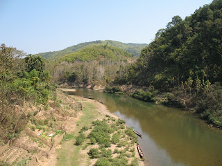
We were not quite sure what to expect interns of the roads and availability of fuel. We have heard that highway 13 that runs the whole length of Laos (China to the north and Cambodia to the south) was now in descent condition. The most of the 380 km was in tight winding mountainous landscape The road just follow the contour of the mountains, no money for bridges except for crossing rivers and took us 8 hours to get to Luang Prabang.

Limestone Mountains of Laos (1)

Rivers are low in the dry season (which is right now) but always popular with the locals (2)

Highway 13 through the mountains (3)

We did find decent fuel along the way and there was a selection of patrol station old (4) and new

Luang Prabang, a 380 km al norte de Vientiane, nuestro proximo destino.
No sabiamos muy bien que tipo, disponibilidad y calidad de gasolina nos esperaba una vez cruzada la frontera.Habiamos oido que la Ruta 13, que recorre el pais de norte a sur uniendo China con Cambodia, era la unica carretera en condiciones aceptables del pais. La mayor parte de los 380 km que unen Vientiane y Luang Prabang transcurre por terreno montanoso y esta lleno de curvas cerradas, pero con paisajes fantasticos. La carretera simplemente sigue el relieve de las montanas, parece que no les dio el dinero para tuneles o puentes que no fueran los estrictamente necesarios para cruzar los rios en el camino. Tardamos nada menos que 8 horas en llegar a Luang Prabang.

Las montanas calizas de Laos (foto 1)
A pesar de que estamos en la estacion seca y los rios corren con niveles bajos de agua, muchos nativos aprovechan para banarse (foto 2).
La autopista 13 (foto 3)
Si que encontramos gasolina decente por el camino, habia bastantes gasolineras, tanto viejas (foto 4) como nuevas


The country's name in the Lao language is "Muang Lao". The French, who made the country part of French Indochina in 1893, called it Lao.This is believe it or not a one party communist state but one will be hard pressed to notice it. It is more or less a free market economy, similar to China (system, not the scale) But it is one of the poorest countries in the South East Asia.Population is just under 6 million, GNI per capita: US $440 (the richer neighbour to the south GNI per capita: US $2,750)The first signs are good. Little traffic on new road leading to the capital Viantiane the 20 or so kms from the border crossing.Viantiane, on the bank of the river Mea Kong, with a Population of a 600,000 has a feel of a small provincial town. There seems to be quite a bit of economic activity taking place these days. Tourism is one of the main sources of income and quite a few tourists visiting Thailand hop in to Laos. And there are also quite a few infrastructure development projects carried out by Thai, Japanese, Korean and the Chinese creating a bit of a economic boom here (very small boom by rest of the world standards).Should not forget to mention the fact that the horn is hardly used here, just like Thailand and the people are very friendly. /

El nombre de Laos en el lenguaje lao es "Muang Lao" (y perdon por la confusion con los distintos laos!). Los franceses, que unieron al pais con la francesa Indochina en 1893, lo llamaron Laos. Aunque no lo parezca, este es un pais comunista. Es mas o menos un pais con economia de libre mercado, parecido a China en el sistema, no en el tamano. Sin embargo es uno de los paises mas pobres del sudeste asiatico. Con una poblacion de menos de 6 millones de habitantes, la renta anual per capita es de US $440, mientras que los tailandeses disfrutan de US $2,750.
De momento la primer impresion es buena: apenas hay trafico en los aproximadamente 20km de carretera nueva qeu va desde la frontera a la capital, Vientiane.
Vientiane, a la orilla del rio Mekong, tiene una poblacion de 600.000 habitantes, y parece una capital de provincias mas que de un pais. NO parece haber mucha actividad economica en la ciudad. El turismo es una de las principales fuente de ingresos de la ciudad; bastantes turistas de visita en Tailandia deciden saltar a Laos por unos dias. Tambien gracias a los tailandeses, y japoneses, coreanos y chinos, se estan construyendo bastantes infraestructuras en la ciudad - y en el pais, creando algo asi como un pequeno boom del ladrillo (un boom bastante pequeno si se compara con los del resto del mundo).
No vamos a olvidar mencionar que aqui, como en Tailandia, tampoco son amantes del claxon - gracias a Dios - y que la gente es muy muy amable y tranquila.


Patuxay, the Arc de Triumphe of Vientiane (Image 3), The black Stupa in the centre of the city (4) , the Stupa That Luang, the national symbol of Laos (in high gloss gold paint, image 5) and the '70 Toyota don't get to retire as they are very popular with taxi drivers(6)

Patuxay, el Arco del Triunfo de Vientiane (foto 3). La estupa negra (foto 4). La estupa de That Luang, el simbolo nacional de Laos (en oro brillante, foto 5). Los toyota de los setenta, que aun no los han jubilado porque gozan de la simpatia de muchos taxistas (foto 6).


Thailand-Laos Border.
Did not spend more than one and half hours to get through both Thai and Laos border crossings ( on either side of the Mea Kong river with a bridge in between)
Had to get Temporary import papers for the bike at the Lao side just like entering Thailand but was lot quicker, The bike insuarnce for 3 weeks $4.00 and covers nothing.
Milage so far 21,630 km
La frontera entre Tailandia y Laos.
No tardamos mas de hora y media en cruzar tanto el lado tailandes como el lao (cada lado en una de las dos orillas opuestas del Mekong, con un puente en medio).
Tuvimos que sacar permisos temporales para importar la moto en Laos, como hicimos cuando entramos en Tailandia. Tambien en la frontera nos sacamos un seguro por 3 semanas que nos costo 4 dolares, aunque la verdad es que creemos que no cubre gran cosa.
El kilometraje hasta ahora: 21.630km

Saturday, February 10, 2007


After 3400km in Thailand (three and half weeks), we enterd Laos on the 10 of Feb. /

Despues de hacer 3400 kilometros en Tailandia (en 3 semanas y media), entramos en Laos el 10 de febrero.


Nong Khai,
Border town on the Thailand side before crossing Mea Kong river (image) to Laos

Friday, February 09, 2007


The northeast Thailand is dotted with underground caves and we could not give this one a miss, not specially when it was full of bats (and their droppings) snakes and 2,000 year old graves (image 2). \

El nordeste de Tailandia esta lleno de cuevas y grutas subterraneas. Nosotros no quisimos perdernos esta en particular, que esta llena de murcielagos (y sus cagarrutillas), serpientes (y sus mudas de piel) y restos funerarios de hace mas de 2000 anos (foto 2)

It was time to enjoy the rural Thailand and we headed northwest towards Mae Hong Sou, the Laos border then towards and down south to Mae Sot along the Burmese border before returning to Sukhothai. No we are not allowed in to Burma and with the state of affairs over there, we don’t think we would like to be there either.The hilly landscape of NE Thailand is a quite a contrast to the south that we have been spending out time up to now. Very rural and most of the population belongs to hill tribes (and still very friendly). Less developed but the roads are excellent. /

Ya iba siendo hora de disfrutar de la Tailandia rural, asi que nos pusimos en camino hacia el nordeste, hacia Mae Hong Son, y desde alli hacia el sur, a Mae Sot, la ciudad fronteriza con Birmania, para finalmente volver a Sukhothai.
Por si os lo estais preguntando no, no nos dejar entran en Birmania, y tal y como estan las cosas con el super-represivo regimen que esta en el poder, casi que no nos importa, no creo que hubieramos ido incluso si nos hubiesen dejado!
Los paisajes del NE de Tailandia son montanosos, bastante diferentes de los del sur en los que habiamos estado hasta ahora. Es una zona muy rural, con casi toda la poblacion viviendo en pequenos pueblos, y perteneciendo a tribus de las montanas (y si, lo habeis adivinado, tambien esta gente son la mar de amable y hospitalaria). A pesar de ser una zona menos desarrollada las carreteras son tambien estupendas, llenas de curvas y vistas espectaculares.


Sunday, February 04, 2007


Chiang Mai, 230km from Sukhothai, literally means new city was founded by King Meng Rai over 700 hundred years ago is the centre of Buddhism in northern Thailand. King Meng Rai himself was very religious and founded many of the city's temples. Unfortunately the temples seems to be going under constant renovation and very little of the old character is reflected in any of the sites. And not to mention the mass of tourist that flock to the place. /


Chiang Mai, a 230km de Sukhothai, su nombre significa "nueva ciudad", fue fundada por el rey Meng Rai hace 700 anos, y es en el centro del budismo del norte de Tailandia. El rey era tambien muy religioso, y construyo muchos de los templos que adornan la ciudad. Es una pena que los templos esten en un permanente estado de mejora (gente pintando, remozando paredes, sustituyendo elementos de madera que se pudren...), lo que hace que parezcan totalmente nuevos, y que pierdan el encanto que tendrian si se pudiera apreciar el paso del tiempo por ellos, por no mencionar los "minolles y minolles" de turistas que hay en cada esquina.